See Japanese monkeys get steamy
One of our favourite Street View sights
this year captures a barrel of Japanese macaques (also known as ‘snow monkeys’)
taking a bath in the hot springs of the Jigokudani (which translates as Hell’s
Valley) Monkey Park. The monkeys descend from the cliffs during the winter to
relax in the steamy spas.

Snow
monkeys are taking a bath in the hot springs of the Jigokudani
Track bird migration on Google Maps
The British Trust for Ornithology (BTO) has
tagged 14 cuckoos in the UK with satellite-tracking devices, so you can follow
their progress as they migrate south for the winter. The map (www.btp.prg/cuckoos) shows the migration
paths of the individual birds, and you’ll find recent updates following the
Welsh cuckoo Lloyd on his journey across Africa. A similar project is mapping
the migration of hummingbirds in the US, based on sightings reported by
birdwatchers.
Explore California’s National Parks
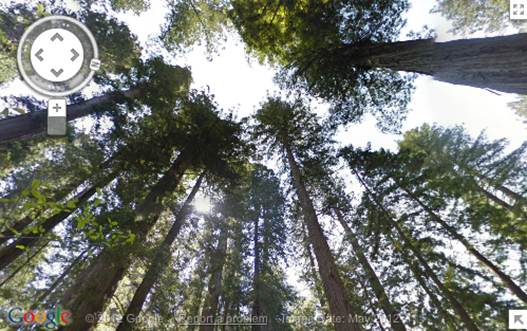
Google has added superb Street View imagery
for five Californian national parks. As well as seeing the tallest trees on
Earth in Redwood National Park and enjoying the view from Old Inspiration Point
in Yosemite, you can take a trip to Death Valley without having to endure the
430C heat.

If
you can't explore California's national parks in person this summer, explore
them from home with Street View
Go on a Street View safari
Street View Safari has some of the best
wildlife shots captures by the Street View cameras. The full-screen slideshow
includes lions, rhinos and giraffes in zoos and safari parks; cattle roaming
the streets of Brazil; and an ostrich apparently fleeing from the Street View
car.
See a smouldering volcano in Hawaii
Street View’s Scenic Hawaii collection offers
some terrific panoramas from the ‘paradise of the Pacific’. Take a virtual
stroll up beautiful beaches, explore the untouched shorelines of Molokai and
get perilously close to a live volcano on Big Island.
Monitor the melting of the north Pole
If you’re worried about the effect of
global warming on the polar ice caps, you can keep tabs on the north Pole at
Arctic.io Observations (www.arctic.io/observations/).
This takes a Google map of the area and overlays satellite images of the
Arctic, taken daily by NASA, so you can look for signs of melting over a period
of months. The map also lets you view details of Arctic settlements, ice drifts
and infrared images.

The
map also lets you view details of Arctic settlements, ice drifts and infrared
images
Find places to swim outdoors
If you’re undaunted by the increasingly nippy
weather and fancy an invigorating alfresco dip, check out Wild Swim
(wildswim.com). This site shows you where to find wild-swimming spots in the UK
and abroad, including outdoor pools, rivers and lakes. The results are colour coded
for easy reference, and you’re told if the spot is safe, family.
Experience coral reefs close up
Street View recently launched its Ocean
project with panoramic imagery of six coral reefs. The underwater locations
include the Great Barrier Reef, Hanauma Bay in Hawaii and the Apo Islands in
the Philippines, which you can explore in detail like a scuba diver. There’s
all manner of amazing sea life to marvel at, from shoals of fish and forests of
anemones to a huge manta ray and a grumpy looking turtle.
Make travel easier
Find nearby bus stops and train stations
One of our favourite new features in Google
Maps for Android provides real-time transport information for wherever you are.
Just zoom into your location, press the Layers button in the top-right corner
and choose Transit Lines. The app shows bus stops, train stations and transport
routes in your area. You can then click a marker for information including
departure times, the distance to a specific stop or station and which lines it
is served by.
View up-to-date traffic information
Google recently expanded its real-time
traffic data to cover more of the UK. To check current conditions from your
browser or mobile device, select Traffic from the Layers menu. Green lines on
the map indicate fast traffic and red ones show low movement, so you can plan
the quickest route accordingly. To check where traffic information is available
in the UK and abroad..
View live Indian railway information
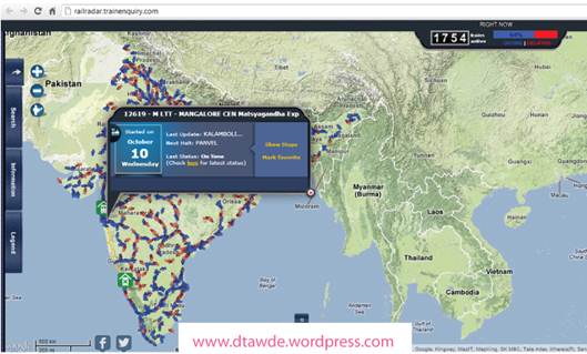
Even if you’re not planning a trip to
India, Rail Radar (railradar.trainenquiry.com) is a mesmerizing site. It
displays real-time updates for the whole Indian rail network on a Google map,
with delayed trains marked in red. Click a train to view its starting point,
destination and next stop.

Rail
Radar it is a live tracker of Indian railway on real-time basis
Get cycling directions and times
Google Maps can help you find the fastest
and safest cycling routes. Zoom into a location, click the Layers menu and
choose Bicycling. Dotted green lines indicated bicycle friendly roads;
light-green lines mark dedicated bike lanes; and dark green lines show car free
bike trails.
To get cycling directions, along with
estimated times and distances, enter your departure point and destination, and
click the Bicycling icon.
Fly planes around the world in real time
If you’ve always dreamed of being a pilot,
you can fulfil your aviation ambitions using the recently updated
Flightradar24.com (www.flightradar24.com).
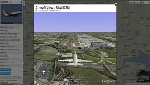
Previously, this brilliant site let you track the position of commercial
flights around the world, but now I also use Google Earth to place you in the
cockpit. Just click one of the planes on the map and select ‘Cockpit view’ to
experience a real-time simulation of the flight. Switch to ‘Aircraft view’ to
see the plane in mid-air.
There’s also a Flightradar24 app for
Android and iOS devices, priced $3.

Real-time
flight tracking website FlightRadar24 has added an awesome new Google Earth
Fly above cities in 3D
One of the downsides to Google Earth’s
satellite imagery is that places often look a bit flat from above. The latest
version of Google Earth for Mobile solves this by letting you ‘fly’ above
entire cities in 3D. the free app uses 45 degree imagery of buildings, terrain
and other elements such as trees to give you a realistic aerial tour.
The app currently provides virtual flights
over Rome, Geneva and several US cities, including Los Angeles, San Francisco
and Seattle, with more to be added soon.
Take a train through the Swiss Alps
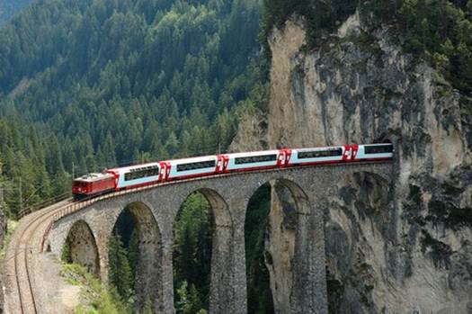
Earlier his year, Google hitched its Street
View trike to the front of the Glacier Express, as the train made its way
between Albula and Bergun in Switzerland. The resulting ‘Train View’ imagery
gives you a breathtaking view of the Swiss Alps, as well as letting you travel
through tunnels and across the Landwasser Viaduct, without having to buy a
ticket!

Take
a train through the Swiss Alps
Check the layout of transport hubs
Avoid confusion at airports and railway
stations by using Google’s Indoor Maps for Mobile. This handy service for
Android devices shows you where to find restaurants, toilets, entrances, shops
and other facilities to ensure you don’t get lost before or after your trip.
You can view floor plans for London stations including Waterloo, Victoria and
King’s Cross; and Edinburgh, Manchester and Luton airports; with more to be
added soon.
To use Indoor Maps, just zoom into a map
until you see a floor plan of the building. You can then press the level switcher
to move between floors.