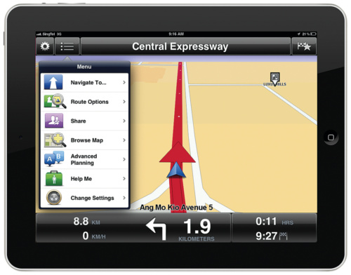
On top of the usual selections, an
interesting and unusual option is “Photos”. If you have enabled geo tagging with
your iPhone’s Camera app, the “Photos” option will show you the way to places
where you have taken photos with your iPhone. Unfortunately, this particular
feature isn’t available on the Android edition.

One
glaring exception is that the TomTom SEA app cannot navigate using postal
codes.
The TomTom SEA app also features
integration with Facebook and Foursquare (again, this feature is iOS-only),
allowing you to quickly navigate to places where your friends have just checked
into. The user can also use the TomTom SEA app to check in on Facebook and
Foursquare or share their location on Twitter or SMS. Users can also use
Facebook, Twitter, SMS or even E-mail to share routes (sorry Android, again,
iOS-only).
In terms of navigational performance, the
TomTom SEA app features the usual navigational aids such as lane assist,
junction view and 3D maps, but it really stands out from the competition
because of its additional navigational technologies, which are unique and
exclusive to TomTom. One standout feature is IQ Routes which help pick the
fastest route possible based on historic speed data. Another is Map Share, a
community map feature that allows users to submit map corrections using their
smartphone. These corrections can then be shared amongst other users.
That said, in terms of actual routing, the
TomTom SEA app did have bewildering route suggestions at times. For example,
while trying to get to Orchard Road from Aljunied MRT, it would stubbornly
insist that we enter the PIE from Paya Lebar Road even if we were already
heading down Geyland Road towards Sims Way.
Lastly, voice navigation is clear and easy
to understand, and the TomTom SEA app comes with multi-language support. Apart
from the usual English, Chinese and Malay, the app also features dialects such
as Cantonese and Hokkien.
All things considered, the TomTom SEA app
is a decent navigational app with some interesting features, though bits such
as “Photos” and integration with Facebook and Foursquare happen to be iOS-only
for now. However, its choice of routes is a little puzzling at times and its
inability to locate destinations using postal codes is a glaring oversight.
·
Developer: Tomtom International BV
·
Version: 1.12 (iOS)
·
Size: 326MB
·
Platform: Android / iOS
·
Price: $64.99 For iOS / $63.99 For Android
And the Best GPS App is...
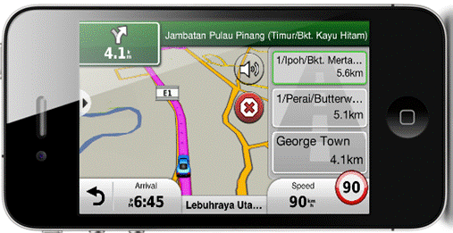
Garmin Streetpilot Onboard SG/MY
The overall winner of this shootout is
Garmin’s StreetPilot Onboard SG/MY app. Navigation performance was one of the
best, thanks to its clear and succinct onscreen and voice instructions, while
its choice of routes were the most logical and sensible. On the flip side, the
app does takes up lots of storage space and it is not as feature-packed as
others. That said, as an app to find the best route to get you quickly and
efficiently from one point to another, it is hard to beat the Garmin
StreetPilot app’s overall functionality and ease of use.
With so much bad press surrounding Apple
Maps, we approached the app with a bit of apprehension. However, we were
pleasantly surprised to find that the app worked well enough, in Singapore at
least. It managed to find addresses and places of interests with ease and
routing was also logical.

The
overall winner of this shootout is Garmin’s StreetPilot Onboard SG/MY app.
Google Maps is easily one of the most
refined free to download GPS apps for both iOS and Android. We like that it
could also look up places of interest and offer reviews and provide contact
numbers. However, both Apple and Google’s GPS solutions require a live data
connection to work. This restricts their usefulness especially if you are
abroad or if your data connection is poor.
In that sense, Nokia’s Drive+ is much more
useful as it lets users download complete maps of countries and regions and can
be used entirely offline. It is a competent navigator, but unfortunately, apart
from offering routes from one point to another, Nokia Drive+ does little else.
Waze is an interesting GPS app with lots of
potential. The best thing about Waze is its ability to provide real-time
traffic updates from other Waze users on the roads. However, this feature
requires a critical mass of users to truly shine, and in Singapore at least,
Waze has yet to reach that magic number.
Finally we come to the TomTom SEA app.
Although pricey, the app is packed with loads of features, integration with
popular social media services, maps of surrounding countries and offers
TomTom’s unique IQ Routes technology. While all of this sounds good on paper,
the app was disappointing in practice mainly because it doesn’t let one search
using postal codes. Furthermore, routing at times was a bit illogical.